Disaster funding for flooding makes local communities safer
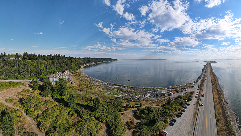
The popular Beach Grove neighbourhood in Tsawwassen is in danger of flooding as a result of climate change which has brought severe storms to the area running along Boundary Bay south of Centennial Beach and north of Point Roberts.
To help secure the community, the local seawall is being reinforced using funding from the National Disaster Mitigation program, a cost-sharing, provincial and federal initiative.
Province-wide, this program has funded $10.8 million to communities undertaking flood-mitigation, risk, and hazard assessment projects.
Top priorities for funding include risk assessments, flood mapping, mitigation planning, and investment in non-structural or small-scale structural mitigation.
Greater Vancouver area projects
City of Delta: $217,000 for a Beach Grove seawall structural assessment and conceptual design for raising the seawall. This will include a geotechnical, seismic, and structural assessment of the seawall, recommendations for short-term remedial actions and preparing conceptual designs for raising the seawall in future.
District of North Vancouver: $125,000 for an Upper Seymour River flood-risk assessment to help plan for structural and non-structural flood mitigation measures for the Seymour River, including lack of right-of way for structural mitigation and slow pace of redevelopment in the area.
City of Richmond: $500,000 for the Steveston Island preliminary dike design to assist with securing the land and obtaining regulatory approvals. The current perimeter dike runs through Steveston Village. Raising the dike there will have major impacts to the existing properties, businesses, and infrastructure. Diking Steveston Island is an alternative.
District of Squamish: $300,000 for pre-design seismic and diking options assessment for upgrading the Squamish River dike adjacent to the Siyich’em Reserve. The goal is to realign the dike to protect and potentially reclaim historic reserve land cut off by the existing dike alignment.
Squamish-Lillooet Regional District: $320,625 to identify and prioritize flood hazard gaps in the existing flood-risk prioritization study completed in 2020. The gaps include flood-related effects of wildfires and identification of road networks vital for use in geohazard-related emergencies.
City of Vancouver: $230,000 for a coastal floodplain subsidence study to the year 2100 which includes natural hazards such as seismic activity, liquefaction, and flooding.
Resort Municipality of Whistler: $169,000 for Van West Creek and Spring Creek flood-mitigation planning that reflects on previously identified risks and provides information about how these creeks would cause extensive flooding of vulnerable communities.
Fraser Basin Council: $903,000 for a Pathways to Action Report to inform decision-makers about actions to reduce flood risk and improve resilience in the Lower Mainland. The report outlines key areas for further discussion and next steps.
GeoBC: $776,820 for a 2021 B.C Floodplain Foundational Data Acquisition. The project provides consistent data and flood plain map standards for communities with outdated or no existing flood plain maps. Data will enable communities to better identify high-risk areas and take appropriate measures for identifying and mitigating risk, including land use and community planning.
- Read the BC government news release about these projects.
- Read British Columbians encouraged to prepare for Spring Flooding.
- Read Province assists communities with flood response, urges people to be prepared.